Chronicles of Mhoriedh
Map 00 Olden Lands Continent
Designed by James Mishler with Jodi Moran-Mishler
Cartography by James Mishler
DriveThruRPG/RPGNow is now offering publishers the opportunity to offer customers a "Pay What You Want" option for download-only products. We figured we'd give this a shot by changing the price of the base continental maps from the standard $2.50 to PWYW. If you pay nothing and find out you liked it, there's nothing from stopping you from going back and buying it again for a couple bucks, just to be nice...
ABOUT THIS PRODUCTThere are seven maps included with this product, each of the same area and detailing different aspects of the Olden Lands. This is “Map 00,” the baseline continental map for the Chronicles of Mhoriedh campaign setting. They are designed for use with the forthcoming Gazetteer of the Olden Lands; they are presented for sale here separately for those who would simply like to have the maps.
MAP 00: MAP SCALE
The official scale on Map 00 is 90 miles per hex, with the map being 30 hexes north to south and 50 hexes east to west. The map is about 2700 miles north to south and about 4500 miles east to west, for a total area of 12,150,000 square miles.
The Continental map will be divided into nine Regional maps. The Regional maps will also have 30 hexes north to south and 50 hexes east to west, and be at a scale of 30 miles per hex.
Each of the nine Regional maps can be divided into nine Area maps, again 30 hexes north to south and 50 hexes east to west. The scale on the Area maps will be 10 miles per hex.
While we plan to release all nine Regional maps, we do not plan on completing all 81 Area maps… though you never know! Wouldn’t that be something?
You are hereby authorized to print any of the maps included with this product for personal use only. Please do not sell, share, or give these maps away, either in electronic or print form, except as excerpts as needed for your personal campaigns.
MAP 00_1: GEOGRAPHICAL PLAIN
This map provides you with the plain geographical and topographical lay of the land. It should be noted that at the 90 mile per hex scale, the indicated feature is simply the majority geographical feature, not necessarily overwhelming all other features in the area. A 90-mile hex has 81 10-mile hexes within its environs; that’s a lot of territory!
MAP 00_2: GEOGRAPHICAL NAMES
This map provides you with the names of the major geographical and topographical features of the Olden Lands. Not every range of hills or river is named, but most of the important ones are, as are all areas mentioned in this product.
MAP 00_3: REGION NAMES
This map breaks the Olden Lands into its major constituent parts. Some of these areas are kingdoms, and some are empires, while others are cultural regions or simple geographic areas, depending on the nature of the civilization prevalent in the region. Those areas shown that are kingdoms are depicted with their “best hoped borders” presented; while claims might be quite grandiose, in many cases such borders are honored more in the breach than in any other fashion. Consult the entries in this volume for more information on each realm and region.
MAP 00_4: SETTLEMENT NAMES
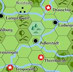
This map shows the location of major settlements. What is a major settlement in one region might well be a rustic hamlet in another. Settlements that are noted with a white star in a red circle are capitals for their respective kingdoms or racial realms, with the exception of Velantia, which is a major free city (and the largest city in the Olden Lands). There are no roads featured at this scale as there are no continental-wide roads. There are in fact few well-developed roads at all; there are some in Elysion, a few in Itlania, and a handful in Kryx, but most folk travel on hard-packed trails or mud-carved wagon ruts.
MAP 00_5: THE GREAT PLAGUE
This map shows the progression of the Great Plague, which began in 1997 AE, preceding and paving the way for the subsequent nomad invasions from Nhorr and the Purple Plains. The plague originated in the Far West and spread to the Olden Lands through traders out of Mhordlakh. It then spread south through the Western Marches and east through Bagaudia. As of the end of the year 2000 AE it has reached the Paynim Coast and Deshret in the South, up through Strigoria, and into the Middle Lands, including Aurlandia and Gregorius. Though it primarily affects humans, other races are not immune, though elves, half-elves, orcs, and half-orcs seem to have strong resistance to the disease.
MAP 00_6: NOMAD INVASIONS
This map shows the major nomad invasions that occurred during the prior three years, with the status of major nomad camps at the end of the campaign season in 2000 AE. This map does not show the minor incursions of the goblinoids from the Northern Wilds and the Starcrag Peaks, or other minor actions on the part of barbarian tribes and other humanoids. The triangle-in-circle symbols indicate current major camps, with the three-dot ruins symbols indicate incursions that were extirpated or otherwise turned back.
MAP 00_7: NINE REGIONS MAP
This map shows the division of Map 00, the Continental Map, into the nine Regional maps. Each of the nine Region maps will be more fully developed in its own larger-scale map and gazetteer.
* Seven Maps *
* PAY WHAT YOU WANT *
* JMG01001 *
Buy it at DriveThruRPG
By it at RPGNow
goblinoidgames.com
A forum for discussion of Labyrinth Lord, Mutant Future, Starships & Spacemen, or other old-school gaming discussion.
Map 00 Olden Lands Continent is now PAY WHAT YOU WANT!
1 post
• Page 1 of 1
Map 00 Olden Lands Continent is now PAY WHAT YOU WANT!
by mystaros » Thu Jun 06, 2013 10:16 pm
James Mishler
Publisher, James Mishler Games
All-Around Good Guy
jamesmishler@gmail.com
http://adventuresingaming2.blogspot.com/
http://jamesmishlergames.blogspot.com/
Hercynian Grimoire #1 is available!
Click here to buy it at DriveThruRPG
Click here to buy it at RPGNow
Publisher, James Mishler Games
All-Around Good Guy
jamesmishler@gmail.com
http://adventuresingaming2.blogspot.com/
http://jamesmishlergames.blogspot.com/
Hercynian Grimoire #1 is available!
Click here to buy it at DriveThruRPG
Click here to buy it at RPGNow
-
mystaros - Posts: 85
- Joined: Wed Dec 15, 2010 11:02 pm
- Location: Appleton, WI
1 post
• Page 1 of 1
Who is online
Users browsing this forum: No registered users and 1 guest